facebook
Mapping the city, Fundamentals & the Knowhow

IEREK Workshop

  • 26, Jun / 28, Jun 2024
  • University of Salento, Italy
Workshop Email
[email protected]
Introduction

In this course, we'll dive into key topics such as GIS and RS applications, cartography, the relationship between GIS and RS, software installation, interface navigation, and the use of essential ArcMap tools. You'll learn how to work with geographical layers, create data frames, and design layouts for producing stunning maps. Our lessons will guide you through understanding shapefiles, their storage, creation, and management using Arc Catalogue.

The art of editing shapefiles and drawing vector data will become second nature, and you'll grasp the difference between saving edits and saving the ArcMap project. We'll also explore the integration of satellite imagery, converting raster to vector through on-screen digitization, and the significance of attribute tables, where you can add and manipulate various data fields.

On-screen digitization will allow you to fine-tune your mapping skills, from adding tabular data to drawn features to classifying and symbolizing them. With this knowledge, you'll be well-prepared to create exceptional maps and deliver final projects that leverage the power of GIS and RS technology.

Instructor

Dr. Mohamed Mehaina is an architect/spatial planner acquiring more than 20 years of academic knowledge and practical experiences related to GIS/RS applications in multi-disciplinary fields. His practice includes professional experience in regional/urban planning, heritage preservation, public health, oil and gas, climate change, and cartography. He also has a long history in education managing GIS capacity building programs.

Graduated in 2001 from Faculty of Engineering, Alexandria University, where he also got his Master’s degree in 2006, in the environmental planning field. Later in 2016, he achieved his Ph.D. in the field of regional planning with special emphasis on using composite indices and advanced spatial planning.

Through his career, Dr. Mehaina participated in extensive national and international strategic development projects related to governmental authorities and international entities like the UNDP, UNESCO and the UNHES. His publications vary from books, articles, atlases, city guides and official national reports. During the period from 2006–2017, he was responsible for the GIS capacity Building Program at the Community Service Programs within the Arab Academy for Science, Technology and Maritime Transportation in Alexandria. Currently working as, the Deputy Director of the Alexandria and Mediterranean Research Center at Bibliotheca Alexandrina. He also serves as the GIS Program Manager at IEREK.

Workshop Outline

Day 1

1. PowerPoint presentation - Introduction to GIS and Remote Sensing (RS) - 1.5 Hrs.

  • What is GIS and RS
  • Applications
  • Cartography and mapping
  • Relation between GIS and RS


2. Introducing the ArcGIS-ArcInfo-ArcMap desktop software from ESRI - 2.5 Hrs.

  • Installing the software
  • Getting familiar with the interface
  • Using ArcMap toolbars
  • Adding and viewing geographical layers
  • Creating data frames and inserting layers
  • Creating layouts and outputting a map


Day 2

3. Understanding the concept of GIS layers (shapefiles) – 1.25 Hr.

  • What is a shapefile
  • Storage of shapefiles
  • Creating shapefiles
  • Managing shapefiles through Arc Catalogue


4. Working with shapefiles – 1.25 Hr.

  • Editing a shapefile / Drawing vector data
  • Snapping
  • Saving edited drawings
  • Understanding the difference between saving the edits and saving the ArcMap project


5. On-screen digitization exercise – 1.5

  • Adding a satellite image raster layer to the ArcMap
  • Creating shapefiles that represent the layers in the raster map
  • Converting raster to vector process through on-screen digitization of the satellite image


Day 3

6. Working with tabular data – 1 Hr.

  • Understanding attribute tables
  • Adding new fields with different types


7. Exercise application, creating a complete GIS for a selected study area – 3 to 5 Hrs.

  • On-screen digitization
  • Adding tabular data to drawn features
  • Classifying and symbolizing draw features
  • Preparing the layout and delivering the final project
Workshop Fees

Held in-person at University of Salento, Italy., the fees below guarantee your attendance for the workshop and all days of the International Conference on Geographic Perspectives on Climate change Mitigation in Urban and Rural Environments 

 
Workshop Attendance  EUR 200
  • Know More about the other GCUE 2024 Workshops here
  • If you’re interested to attend more than 1 workshop, ask for your discount ([email protected])
  • Special prices are available for University of Salento, Italy.
Venue
University of Salento
Piazza Tancredi, 7, 73100 Lecce LE, Italy.
 

Your Trip To Lecce

Lecce is famous with the best-knowns sights in Italy that it would take weeks to see everything in it, also it is one of Europe’s most popular cities. It has many breathtaking views and tourist attractions from museums to churches and palaces.

The following are some suggestions of places to visit while you are in Lecce, Italy:

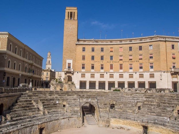
Roman Amphitheatre in Piazza Sant’Oronzo

The highlight is the large Roman amphitheatre which once seated 14,000 spectators on its two tiers, although only the lower tier remains. Sometimes concerts still take place here.

In the piazza, you can also see the column of Sant’Oronzo and an unusual 20-meter-high bronze clock, the Orologio Delle Meraviglie, created in 1955 on the wall of the Banco di Napoli.
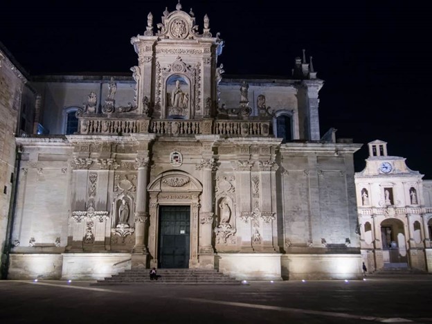
Lecce Cathedral

Lecce’s Cathedral is on one of the most beautiful squares in Lecce, the Piazza del Duomo.

Piazza del Duomo has a more intimate feel and is enclosed by ornate buildings including the bishop’s residence and seminary.

The Cathedral was originally built in 1144 and was rebuilt in the 17th century by architect Giuseppe Zimbalo in the decorative baroque style that now characterises the city.
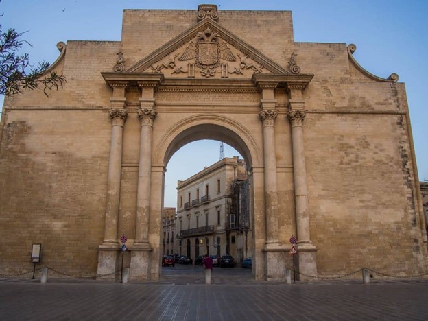
Lecce’s Portas

The three remaining city gates of the previously walled city are useful landmarks for navigating the city, and all are decorative and worth seeing.

Once you pass through the gates, you leave the historic centre behind for the modern part of the city which is less attractive, but it does have some good restaurants and shops.

The main city gate is Porta Napoli built in 1548 for a state visit from Charles V and modelled on a Roman triumphal arch. Just outside the arch is the obelisk and beyond this is the university area.

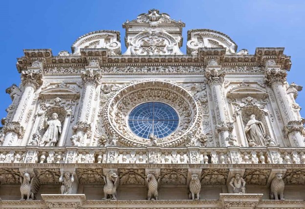
Basilica di Santa Croce

Lecce’s most extravagant baroque church is Santa Croce, also designed by Zimbalo. If you only visit one church in Lecce, make it this one.

The facade features intricate carved figures and a rosette window, and inside are ornate columns and a decorative ceiling, next to Santa Croce is another Zimbalo creation, the Palazzo dei Celestini, now the seat of the local government.

After admiring the exterior, you can walk through the courtyard and out the archway to reach Lecce’s park, just beyond the church and palace is a lovely little street full of wine bars—perfect for a light lunch or aperitivo.


Travel Information

By Train

You can reach Lecce easily by direct Trenitalia train from cities such as Brindisi (30 minutes), Bari (1.5 hours), Rome (5.5 hours), and Bologna (7 hours). From Naples you’ll have to change trains at Caserta (5.5 hours total).

You can check timetables and book tickets in advance for the best rates from the Trenitalia website. You need to use Italian place names (i.e. Torino not Turin). 

The Bari to Lecce Trenitalia train stops at a number of places in Puglia including Polignano a Mare, Monopoli, Cisternino, and Ostuni.

By Plane

The nearest airport to Lecce is Brindisi (30-minute drive), while Bari airport is a 2-hour drive away.

You can rent a car at Brindisi airport or take a shuttle bus from the airport to Lecce (40 minutes).

By Car 

From Bari (150Km), via a freeway. Just follow the signs to Brindisi-Lecce. Rental cars are available in the main Italian airports, including the airports of Brindisi and Bari. This could be a good idea if you wish to join a visit to the South of Italy to the conference.

Overview

As one of the leaders and most avid supporters of the research and academic community, IEREK has always endeavored to develop and enrich innovative production. Constantly advocating for forward-thinking became our modus operandi.p>

Because of this driving passion, we've hosted many successful workshops where participants were able to widen their horizons and feed their love of their craft using real-life applications and concentrated, global, expert knowledge. We've hosted schools abroad in such locations as culturally rich Italy and the diverse United Kingdom, where our future architects received an enriching and engaging learning experience on subjects.

It has taught us what one could gain from investing in themselves. Studying overseas has many fantastic benefits, from helping you find a good job to improving your social life. A few of these benefits are compiled here.