
Why remote sensing matters (and fast)
Imagine spotting a small change in a river basin that, if ignored, becomes a week later a devastating flood. Remote sensing (satellites + UAVs + sensors) turns tiny signals into early warnings — saving lives, money, and ecosystems. Below we break down the tech, how it’s used, and real-life use cases.
1. Wide-area monitoring & early warning with satellites
Satellites are the country-sized cameras in the sky. They provide constant, repeated views of broad areas — perfect for tracking floods, droughts, deforestation, and large wildfire plumes.
- Large-scale scanning: Satellites deliver time-series images that reveal trends (vegetation decline, glacier retreat, urban sprawl).
- SAR (Synthetic Aperture Radar): can see through clouds and at night — indispensable for floods and landslide detection when optical sensors are obstructed.
- Predictive analytics: Historical satellite records combined with machine learning can highlight regions likely to face hazards so authorities can act early.
2. Local, high-detail insight with drones (UAVs)
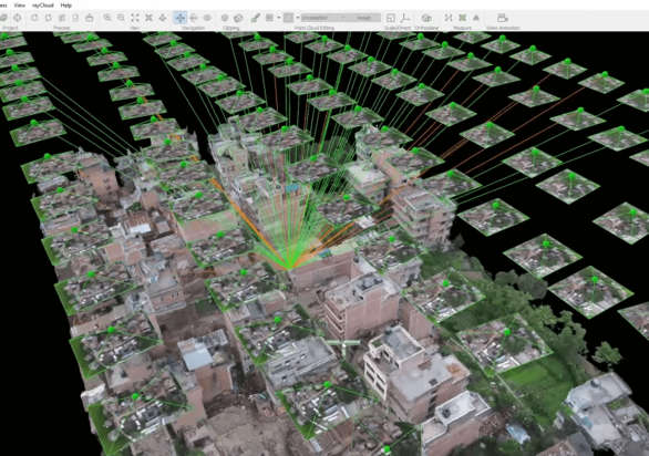
Drones bring the zoom. Where satellites may be too coarse or blocked by clouds, UAVs fly low and capture ultra-high-resolution images and 3D models.
- High-resolution mapping: Photogrammetry and LiDAR from UAVs produce precise Digital Elevation Models (DEMs) for flood path and landslide modeling.
- Rapid damage assessment: After earthquakes, floods, or storms, drones map damage hotspots so rescue and repair teams know where to go first.
- Flexible deployment: Drones are on-demand and cost-effective for local surveys, habitat monitoring, and infrastructure inspections.
3. Remote sensing + AI/ML — the synthesis that scales
Raw images are useful. Automatic detection at scale is a game-changer. AI and deep learning scan imagery for features that matter: flooded roads, burned areas, collapsed buildings, or early vegetation stress.
- Change detection: Automated time-series analysis flags areas that show unusual trends over weeks or months.
- Classification & alerts: Neural networks classify land cover, detect hotspots, and trigger near-real-time alerts for responders.
- Data fusion: The most reliable predictions come from fusing satellite, drone, ground sensors, and weather model outputs.

4. Practical examples & wins
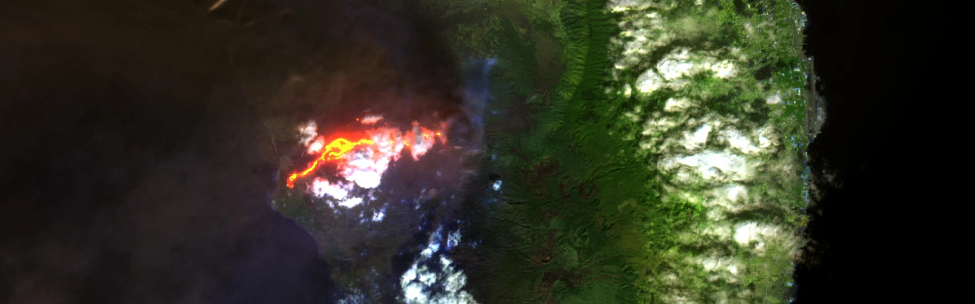
- Wildfires: Satellites detect thermal anomalies and smoke plumes; drones validate hotspots and map perimeter for firefighters.
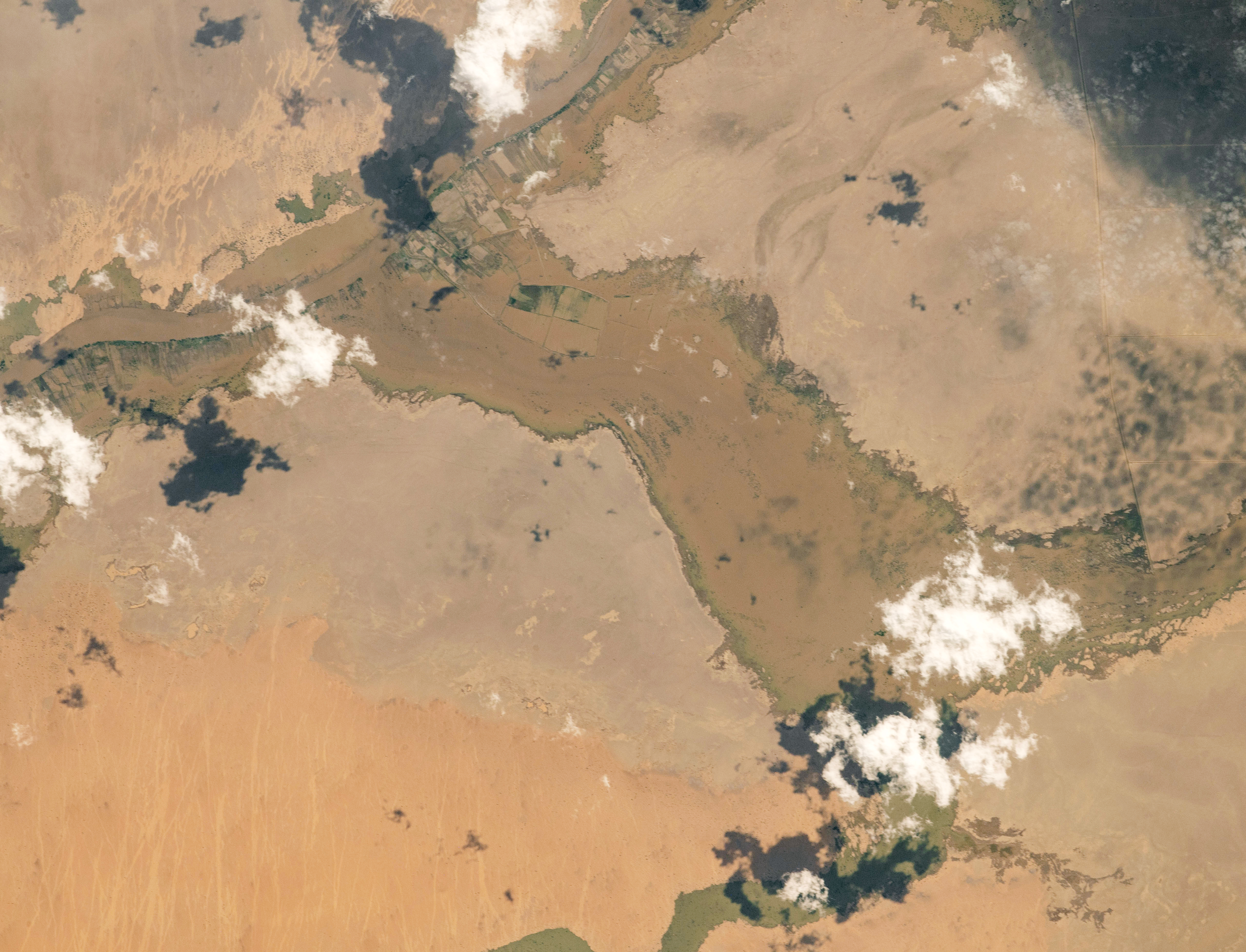
- Floods: Satellite-based river monitoring + UAV depth mapping helps emergency managers estimate affected areas and prioritize evacuations.
- Landslides: Drone-derived DEMs combined with satellite soil-moisture and rainfall records identify slopes at highest risk.
Challenges to be aware of
This tech is powerful — but not magic. Barriers include huge data volumes, cost/availability of very high-resolution imagery, weather limitations, and the need to train local teams to interpret and act on the data.
Why this matters to MENA
MENA countries face acute water stress, rapid urban growth, and diverse geohazards. Putting satellite and UAV insights into local decision-making turns science into safety: better early warnings, targeted adaptation, and smarter recovery.
In short: the difference between a slow response and a timely one often comes down to the right data at the right time.
Want to publish or dive deeper?
If you’re preparing a blog, report, or conference talk, use these keywords for SEO: remote sensing, satellite imagery, UAV, disaster prediction, flood mapping, SAR, Earth observation. Add local case studies to make the piece pop for MENA audiences.
References
- “The Basics of Earth Observation: From Satellites to Drones” — Birdi. (2023). Available: https://www.birdi.io/blog-post/the-basics-of-earth-observation-from-satellites-to-drones
- “6 Highly Effective Ways Satellites Help Utilities & Disaster Management” — AiDash. (2024). Available: https://www.aidash.com/6-highly-effective-ways-satellites-help-utilities-disaster-management
- “Disaster Management Applications of UAVs” — Drones (MDPI). (2023). Available: https://www.mdpi.com/2504-446X/7/1/32
- “Satellite Imagery for Emergency Management” — European Space Imaging (EUSI). (2024). Available: https://www.euspaceimaging.com/blog/2024/07/01/satellite-imagery-for-emergency-management
- “Natural Disasters and the Role of Remote Sensing” — EOS Data Analytics. (2021). Available: https://eos.com/blog/natural-disasters-2021
- “Deep Learning for Disaster Response using Satellite Imagery” — arXiv. (2021). Available: https://arxiv.org/abs/2104.14006